Siquijor Geology: Fossils, Limestone & the Ancient Seabed Beneath Your Feet
Explore Siquijor's geological history: marine fossils in limestone cliffs, how the island rose from the ocean floor, and the best spots to see ancient rock formations.
Most visitors come to Siquijor for turquoise waters, jungle waterfalls, and the mystique of an island steeped in folklore. Few realize they are walking on a natural history museum millions of years in the making. Beneath the tropical greenery and white sand, Siquijor is a raised coral platform — an ancient seabed pushed above the waves by tectonic forces over countless millennia. The evidence is everywhere if you know where to look: giant clam fossils embedded in roadside rock cuts, coral formations frozen in limestone walls, and cave systems carved by millennia of dissolving carbonate.
This guide takes a different lens to the Mystic Island, one that reveals how Siquijor was built, layer by geological layer.
How Siquijor Rose from the Sea
Siquijor belongs to the Central Visayas volcanic arc, but unlike its neighbors Cebu and Negros, the island is not primarily volcanic. Instead, it is a textbook example of a raised coral reef platform sitting atop a volcanic basement. The deeper layers consist of ancient volcanic rock — basalt and andesite deposited during submarine eruptions millions of years ago. Over time, shallow tropical seas allowed massive coral reefs to flourish on top of these volcanic foundations.
Through a process geologists call tectonic uplift, the Philippine Sea Plate’s movements gradually pushed these reef structures above sea level. The result is the island you see today: a relatively flat, elevated limestone plateau ringed by younger coral terraces that step down toward the coast. Mount Bandilaan, the island’s highest point at 557 meters, marks the remnant volcanic core around which the coral platform accumulated.
This uplift happened in stages, which is why Siquijor has distinct terraces visible along its coastline. Each terrace represents a former shoreline, now elevated meters or even tens of meters above the current sea level. The oldest and highest terraces are found in the island’s interior, while the youngest formations line the present-day coast.
Reading the Rocks: What You Will Find
The dominant rock type on Siquijor is coralline limestone — a sedimentary rock composed almost entirely of the skeletal remains of marine organisms. Within this limestone, you can find remarkably well-preserved fossils that tell the story of the ancient reef ecosystem.
Giant Clam Fossils (Tridacna)
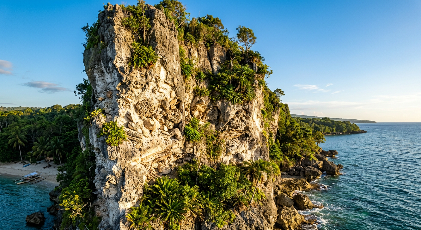
The most dramatic fossils on Siquijor are the Tridacna giant clam shells embedded in limestone exposures across the island. Some of these specimens measure over half a meter across, their distinctive wavy shell margins perfectly preserved in the rock. You can spot them in road cuts along the interior highways, particularly on the roads climbing toward Mount Bandilaan. The shells appear as pale, ribbed shapes set against the darker limestone matrix, and once you train your eye to recognize them, you will start seeing them everywhere.
Coral Head Formations
Entire coral colonies are preserved in cross-section within the island’s limestone. Brain corals, staghorn corals, and massive dome-shaped Porites colonies appear as textured circular or branching patterns in exposed rock faces. The best examples are visible in coastal cliff exposures, particularly along the northeastern and southeastern shorelines where wave erosion has cut fresh faces into the limestone.
Marine Gastropods and Bivalves
Smaller but equally abundant are the shells of marine snails, clams, and other mollusks scattered throughout the limestone. These are often visible as small spiral or rounded shapes in any freshly broken or naturally eroded rock surface. Coastal areas around Lazi and Maria municipalities have particularly rich concentrations.
Echinoid Impressions
Sea urchin tests — the rigid skeletal structures — leave distinctive circular impressions in the limestone. Though harder to spot than the larger fossils, patient observers can find their five-pointed star patterns on flat limestone surfaces, especially in areas where foot traffic or water flow has naturally polished the rock.
The Karst Connection
Siquijor’s limestone geology directly creates many of the island’s most celebrated features. Limestone is solite in slightly acidic rainwater, and over thousands of years, this dissolution process creates what geologists call karst terrain.
Caves
The island’s cave systems, including the well-known Cantabon Cave, are dissolution cavities formed as rainwater percolated through cracks in the limestone, gradually widening them into passages and chambers. Inside these caves, you can see the geological process in real time: stalactites growing downward from dissolved calcium carbonate dripping from the ceiling, stalagmites building upward from the floor, and flowstone formations cascading down cave walls like frozen waterfalls of stone.
The dry season months of March through May are the best time to explore Siquijor’s caves. Water levels are lower, passages that might be flooded during the wet months become accessible, and the reduced mud makes for safer footing.
Springs
Siquijor has an unusual abundance of freshwater springs for an island its size. This is a direct consequence of the porous limestone geology. Rainwater soaks into the limestone surface, filters through the rock, and re-emerges where the limestone meets the less permeable volcanic basement rock below. These spring lines often occur at predictable elevations around the island, creating the reliable water sources that have supported human settlement for centuries.
The mineral-rich water that passes through limestone dissolves calcium and magnesium carbonates along the way, giving Siquijor’s spring water its characteristic clean taste and slight mineral quality.
Sinkholes and Dolines
Less dramatic but geologically significant are the circular depressions that dot the island’s interior. These sinkholes, or dolines, form when underground dissolution creates a void in the limestone that eventually causes the surface to collapse. Some of Siquijor’s sinkholes have become small ponds or agricultural plots, their naturally fertile soil and water-retaining properties making them productive growing areas.
Where to See Siquijor’s Geology Up Close
Road Cuts Along the Interior Highway
The most accessible geological exposures are found along the roads that cross the island’s interior, particularly the routes connecting the coastal ring road to the upland areas around Mount Bandilaan. Construction crews have cut through limestone layers, exposing cross-sections of fossil-rich rock. The road from San Juan climbing toward Cantabon has several excellent exposures showing distinct coral and shell fossils.
Pull over safely where you see pale, stratified rock faces along the road. Look for the telltale wavy lines of giant clam shells, the rounded patterns of coral heads, and the scattered shapes of smaller marine fossils. Bring a magnifying glass or zoom with your phone camera to see fine details.
Coastal Cliff Exposures
The eastern and southern coastlines of Siquijor have sea cliffs where wave action has carved into the limestone, creating fresh exposures of fossil-rich rock. The area around Kagusuan Beach and the cliffs near Lazi offer particularly good examples. At low tide, you can walk along the base of these cliffs and examine the rock face at eye level, finding fossils that have been exposed by centuries of marine erosion.
Cave Interiors
Inside Cantabon Cave and the island’s other accessible cave systems, you can see the full spectrum of karst features. Stalactites and stalagmites demonstrate the ongoing process of limestone dissolution and re-deposition. Some cave passages have walls studded with fossilized corals and shells, visible in the beam of a headlamp. A knowledgeable local guide can point out specific geological features and explain the local names given to distinctive formations.
Mount Bandilaan National Park
The trails ascending Mount Bandilaan traverse different geological layers, from younger coastal limestone at the base to the older volcanic rocks near the summit. This natural cross-section of the island’s geological history is one of the most educational walks available on Siquijor. Notice how the vegetation changes as the rock type shifts — the thin, alkaline soils of the limestone support different plant communities than the deeper, more acidite soils of the volcanic zone.
Tulapos Marine Sanctuary Coastline
The rocky shoreline near Tulapos offers an accessible spot to examine the youngest limestone formations on the island. Here, you can see how modern coral rubble is being cemented into rock in real time, providing a tangible connection between the living reef offshore and the fossil reef that forms the island itself. Tide pools carved into the limestone platform reveal both geological and marine biology simultaneously.
Practical Tips for Geological Exploration
Timing matters. The dry season, particularly March through May, is ideal for geological exploration. Exposed rock faces are dry and easier to examine, cave conditions are safer, and the clear weather provides better visibility for spotting formations in cliff faces.
Bring the right tools. A magnifying glass or hand lens reveals fine fossil details invisible to the naked eye. A phone with a good macro camera mode works well for documenting finds. A small field notebook helps you record locations and descriptions of interesting formations.
Do not collect. Philippine law protects geological and paleontological specimens. Leave all fossils in place. Photographing them is the responsible alternative, and your images can contribute to citizen science databases that help researchers catalog the island’s geological heritage.
Hire a local guide. For cave explorations and interior hiking, local guides are essential for safety and invaluable for knowledge. Many Siquijor guides have grown up exploring the island’s geological features and can point out formations you would otherwise walk past.
Combine with other activities. Geological exploration pairs naturally with hiking, caving, and even beach time. Every coastal walk and mountain trail on Siquijor offers geological observation opportunities. Once you start noticing the fossils and rock formations, they transform every ordinary outing into a journey through deep time.
The Bigger Picture
Understanding Siquijor’s geology adds depth to every experience on the island. The springs that feed Cambugahay Falls flow because of the limestone’s permeability. The caves that draw adventure travelers exist because rainwater dissolved ancient coral. The flat coastal terraces where villages are built represent former shorelines from warmer geological periods when sea levels were higher.
Even the island’s famous mystical reputation has geological roots. The bioluminescent organisms that historically gave Siquijor its “Island of Fire” reputation thrive in the mineral-rich waters that seep through the limestone before reaching the sea. The dense tropical forest that cloaks the interior and contributes to the island’s sense of otherworldly enchantment grows on soils derived from both volcanic and limestone parent rock, creating a botanical diversity unusual for an island of this size.
Siquijor is not just a beautiful tropical destination. It is a geological story written in stone, a record of ancient oceans, tectonic forces, and the patient work of coral organisms over millions of years. Every cliff face, every cave chamber, and every fossil-studded road cut is a page in that story, waiting for a curious traveler to read it.
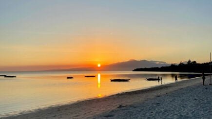
The next time you stand on a Siquijor shoreline watching the sunset, consider this: the very rock beneath your feet was once a living reef, teeming with marine life in a shallow tropical sea that existed long before humans walked the earth. The island you are visiting was built by organisms no larger than your fingertip, one calcium carbonate skeleton at a time, across an expanse of time that dwarfs all of human history.
That perspective — geological time meeting human experience — is perhaps the most profound souvenir you can take home from the Mystic Island.
Siquijor.xyz Editorial Team
Local experts sharing authentic Siquijor experiences
Related Experiences

Budget Travel Siquijor: Complete Money-Saving Guide
How to experience Siquijor on a budget - cheap accommodations, free attractions, money-saving tips, and sample budgets for backpackers.
Romantic Siquijor: A Couples & Honeymoon Guide
Plan the perfect romantic getaway in Siquijor. Secluded beaches, sunset dinners, couples activities, and the best accommodation for an intimate island escape.
Digital Nomad Guide to Siquijor: Remote Work in Paradise
Everything remote workers need to know about working from Siquijor: internet, coworking, accommodation, costs, and whether this island suits nomad life.