Siquijor Drone Photography Guide: Rules, Best Aerial Spots, and Tips for 2026
Complete guide to drone photography on Siquijor Island. CAAP regulations, best aerial spots, flight tips, and seasonal advice for stunning shots.
Siquijor Island looks extraordinary from ground level. From above, it becomes something else entirely. The interplay between deep ocean blues, shallow reef turquoise, white sand crescents, and dense tropical canopy creates compositions that simply cannot be captured from any vantage point on the ground. A drone opens up Siquijor in ways that even the best clifftop viewpoints cannot replicate.
But flying a drone on a small Philippine island is not as simple as powering up and lifting off. Regulations, no-fly zones, weather patterns, and local sensitivities all need to be understood before you unpack your aircraft. This guide covers everything you need to know about drone photography on Siquijor Island in 2026, from the legal requirements to the best locations for breathtaking aerial shots.
Philippine Drone Regulations: What You Need to Know
The Civil Aviation Authority of the Philippines (CAAP) governs all unmanned aerial vehicle operations in the country. Whether you are a tourist with a consumer drone or a professional cinematographer, the same baseline rules apply.
Registration and Permits
All drones weighing more than 250 grams must be registered with CAAP before being flown in Philippine airspace. This includes the DJI Mini series (which sits right at the 249g threshold for some models), DJI Air, Mavic, and any larger platforms. Registration can be completed online through the CAAP Unmanned Aircraft Systems portal, though processing times vary. Plan to register at least two weeks before your trip.
For recreational flights, a CAAP registration is generally sufficient. Commercial drone operations, including any footage you plan to sell, license, or use in paid productions, require an additional Special Flight Permit. The process involves submitting flight plans and proof of insurance.
General Flight Rules
CAAP mandates the following baseline rules for all drone operations in the Philippines:
- Maximum altitude of 120 meters (400 feet) above ground level
- Visual line of sight must be maintained at all times
- Minimum distance of 30 meters from people, vehicles, and structures not involved in the operation
- No flying over crowds or public gatherings
- No flying within 10 kilometers of any airport or aerodrome without explicit CAAP authorization
- No night flights without special authorization
- No flying in restricted or prohibited airspace
Siquijor-Specific Considerations
Siquijor has its own small airport (Siquijor Airport, SQJ) located in the municipality of Siquijor near Dumanhog. If your drone weighs more than 250 grams, you technically need CAAP clearance to fly within 10 kilometers of this airport. Given Siquijor’s small size (approximately 13 by 19 kilometers), much of the western portion of the island falls within this radius. In practice, the airport handles very limited commercial traffic, but the regulation exists and should be respected.
The Siquijor LGU has not enacted specific municipal drone ordinances as of early 2026, but individual barangays and tourism sites may restrict drone use at their discretion. Always ask before flying at managed attractions.
Best Aerial Photography Locations
Siquijor offers a remarkable diversity of aerial subjects for an island of its size. The following locations represent the strongest opportunities for drone photography, organized by region.
Paliton Beach and the Western Coastline
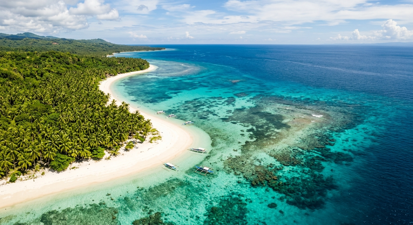
Paliton Beach is arguably the single best drone photography location on Siquijor. The beach itself is a narrow crescent of white sand bordered by a famous row of coconut palms on one side and a gradient of aquamarine to deep blue water on the other. From directly above, the contrast between the palm shadows stretching across the sand and the color shifts in the water creates images that are immediately recognizable.
Fly at sunrise or within two hours of sunset for the longest shadows and warmest light. A straight-down (nadir) perspective at about 50 to 80 meters altitude captures the full length of the palm-lined shore while keeping the water’s color gradients visible.
The coastline west from Paliton toward Tubod Marine Sanctuary offers additional opportunities: rocky headlands, small hidden coves, and sections where the reef comes close to shore, creating striking patterns visible only from above.
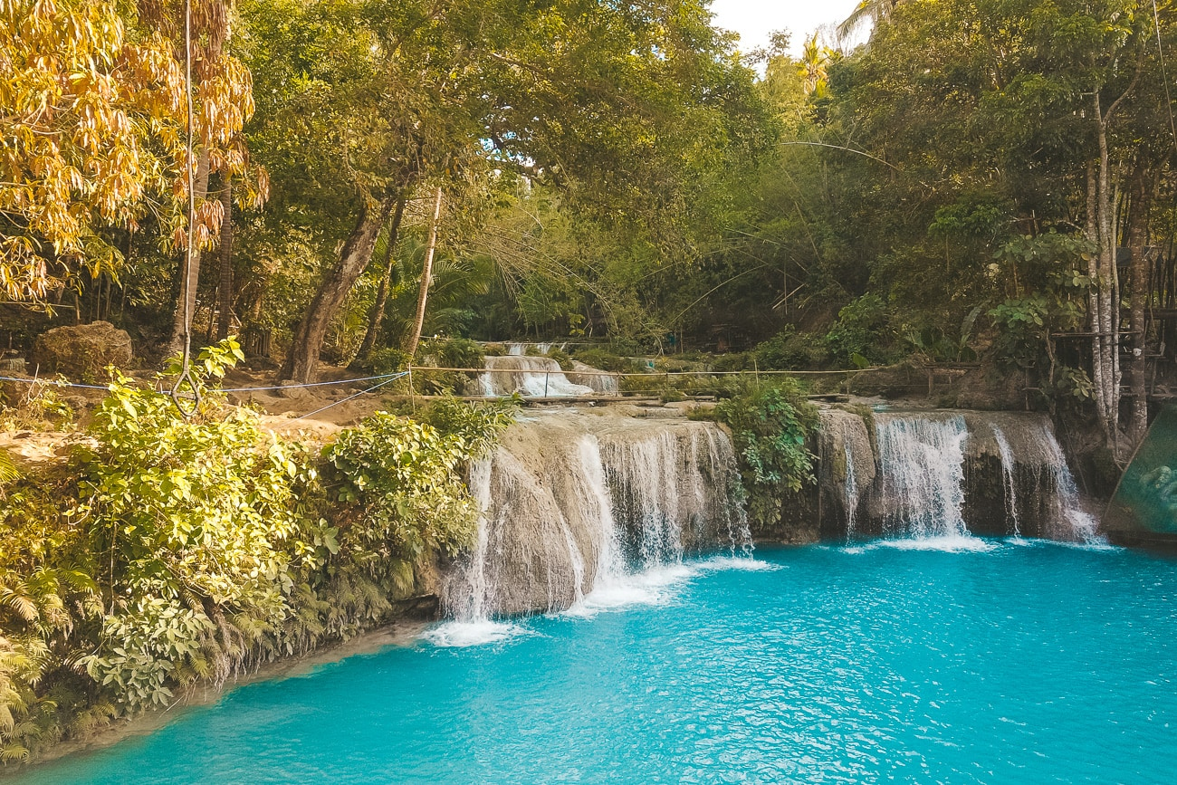
Cambugahay Falls from Above
While most visitors experience Cambugahay Falls from the pool below, a drone reveals the full cascade system in context. The falls descend through three main tiers surrounded by dense jungle canopy, and the emerald pools stand in dramatic contrast to the surrounding green. The turquoise water color is most vivid around midday when direct sunlight penetrates the canopy gaps.
Note that Cambugahay Falls is a managed tourism site. As of 2026, there is no formal drone ban, but the site management may request that you do not fly during peak visitor hours (roughly 10 AM to 3 PM) when crowds are dense below. Early morning flights, ideally before 8 AM, are best both for light and for avoiding disruption to other visitors.
Salagdoong Beach and Cliff Area
The elevated limestone cliffs at Salagdoong provide a natural drama that translates powerfully to aerial photography. The cliff-jumping platforms, the deep blue water at the base of the cliffs, and the surrounding forested headland create a composition with genuine depth and scale.
A side-angle approach from offshore, capturing the cliff face and the water together, tends to produce more compelling images than straight overhead shots here. Fly at 40 to 60 meters altitude for a perspective that includes both the cliff top and the water surface below.
Salagdoong is managed by the provincial government. Ask at the entrance booth about current drone policies before flying.
Mount Bandilaan Summit and Interior Highlands
The interior highlands around Mount Bandilaan offer a completely different aerial perspective from the coastal shots. From above the summit area (521 meters elevation, the island’s highest point), you can capture panoramic views showing the entire island surrounded by ocean, with neighboring Cebu, Negros, and Bohol visible on clear days.
The butterfly sanctuary, forest trails, and the stations of the cross leading to the summit all make interesting aerial subjects. Morning flights before 9 AM are essential here, as clouds typically build over the highlands by late morning during the dry season.
San Juan Coastline and Marine Sanctuaries
The San Juan coast, particularly around Tubod Marine Sanctuary and the beach resort strip, offers a different aesthetic. The shallow reef systems here create remarkable patterns when viewed from above: dark seagrass beds, bright sand channels, and the shifting blue gradients of deeper water beyond the reef edge.
Fly over the sanctuary areas at sufficient altitude (80 meters or above) to avoid disturbing marine life or snorkelers in the water below. The patterns are best photographed between 10 AM and 2 PM when the sun is high enough to illuminate the seafloor through the water.
Kagusuan Beach and the Eastern Shore
The eastern coastline between Lazi and Maria is dramatically different from the west. Rocky limestone formations, small wave-cut platforms, and narrow beaches backed by dense vegetation create a wilder, less manicured aesthetic. Kagusuan Beach, reached by a steep staircase, is a particularly photogenic spot from the air: a small sandy cove hemmed in by dark rocks with water that shifts from pale turquoise to deep blue within meters.
Lazi Church and Heritage Complex
The San Isidro Labrador Church and the adjacent convent in Lazi (the largest convent in Asia) form an impressive aerial subject. The scale of the convent building relative to the surrounding town is difficult to appreciate from ground level. A drone at 60 to 80 meters reveals the full footprint of the complex, the relationship between the church and the sea, and the surrounding streetscape of the historic town center.
Cultural and religious sites require particular sensitivity. Do not fly during Mass or other services, and keep a respectful distance from the structures themselves.
Seasonal and Weather Considerations
Dry Season (February to May)
The dry season offers the most reliable flying conditions. Clear skies, minimal wind at ground level, and the best water clarity for reef photography all coincide during these months. April, in particular, tends to offer excellent visibility with relatively calm conditions.
However, thermal activity builds through the day during the dry season, especially over the interior highlands. Morning flights (6 AM to 9 AM) consistently produce the calmest conditions and the best light for most coastal subjects.
Amihan Season Wind Patterns
Even during the dry months, Siquijor experiences the northeast monsoon (amihan) winds, which can be significantly stronger at altitude than at ground level. A day that feels calm on the beach may have 25 to 35 kilometer-per-hour winds at 100 meters altitude. Always check wind conditions at your planned flight altitude using a weather app that provides altitude-specific forecasts, or simply ascend slowly and monitor your drone’s stability before committing to a flight plan.
The western coastline (Paliton, San Juan) is more sheltered from amihan winds than the eastern shore (Lazi, Maria). Plan your eastern coastal flights for the calmest mornings.
Light Conditions
Siquijor sits at approximately 9 degrees north latitude, which means the sun is nearly directly overhead during the middle of the day in April and May. This overhead light is excellent for straight-down reef photography but harsh for landscape compositions. Golden hour light (the first and last hour of sunlight) creates long shadows that add dimension to coastal and village scenes.
Sunrise on Siquijor during April occurs around 5:45 AM and sunset around 6:10 PM. Plan your flights accordingly.
Equipment Recommendations
Best Drones for Siquijor
For travel to a remote island where luggage space and weight matter, the DJI Mini series remains the most practical choice. The 249-gram weight keeps you under the threshold for some regulations, the image quality is more than sufficient for social media and web use, and the compact form factor packs easily.
For serious aerial photography or videography, the DJI Air series offers a meaningful step up in camera quality (larger sensor, better dynamic range) while remaining portable enough for island travel. The DJI Mavic series provides professional-grade results but adds significant weight and bulk to your travel kit.
Essential Accessories
Bring more batteries than you think you need. Siquijor’s heat and humidity reduce battery performance, and charging infrastructure outside of resorts can be limited. Three to four batteries is a reasonable minimum for a dedicated drone photography trip.
A set of ND (neutral density) filters is valuable for video work, allowing you to maintain cinematic frame rates in bright tropical sunlight. For stills photography, ND filters also enable longer exposures for smooth water effects, though this requires very calm conditions.
A portable landing pad prevents sand and dirt from being kicked into the motors during takeoff and landing on Siquijor’s beaches. The investment in a simple folding pad protects your equipment and extends its lifespan.
Etiquette and Best Practices
Drone photography on a small island requires a higher degree of social awareness than flying in remote wilderness areas. Siquijor’s communities are welcoming but also private. Do not fly over residential areas without clear purpose, and never hover over people’s homes or private property.
At tourist sites, be mindful that the sound of a drone can disrupt the experience for other visitors seeking tranquility. Keep flights short and purposeful at popular spots, especially at places like Cambugahay Falls and Salagdoong Beach where people come for the peaceful atmosphere as much as the scenery.
If someone asks you to stop flying, comply without argument. Building goodwill for the drone photography community matters more than any single shot.
When posting aerial images of Siquijor on social media, credit the island and include practical information that benefits local tourism. The photography community and the island’s economy both benefit when stunning aerial work draws more visitors.
Post-Processing Tips for Siquijor Aerials
Tropical island aerial photography benefits from specific post-processing approaches. The water color in Siquijor tends to photograph slightly greener than it appears to the eye, so a subtle shift toward blue in the aqua and teal channels often produces more accurate results.
Reduce haze in post-processing rather than fighting it with polarizing filters (which are impractical on most consumer drones). The dehaze slider in Lightroom or similar tools is remarkably effective at cutting through the tropical atmospheric haze that builds through the day.
For straight-down reef photography, increase clarity and texture to bring out the patterns in the coral and seagrass. For landscape compositions, ease back on clarity to maintain the soft, atmospheric quality that gives tropical island images their character.
Planning Your Drone Photography Trip
A dedicated drone photography visit to Siquijor works best over four to five days, giving you enough mornings and evenings to work through the best locations and account for variable weather. Base yourself in San Juan for easy access to the western coastal spots, with day trips to Lazi and the eastern shore.
Check the CAAP registration status of your drone before you leave home. Bring printed copies of your registration and any permits. Carry a fully charged phone with your registration details accessible offline in case you need to show documentation at a tourism site.
Siquijor rewards patience and preparation. The best aerial images of the island come not from aggressive flying and rapid-fire shooting, but from understanding the light, the weather, and the landscape well enough to be in the right place at the right moment. Give yourself that time, and the results will speak for themselves.
Siquijor.xyz Editorial Team
Related Experiences
Cambugahay Falls Photography: A Masterclass in Waterfall Shots
Perfect your waterfall photography at Siquijor's most famous falls. Camera settings, composition tips, and techniques for capturing the iconic rope swing.
15 Most Instagrammable Spots in Siquijor (With GPS Coordinates)
Find the most photogenic locations in Siquijor for stunning social media content. Exact locations, best times to shoot, and tips for each iconic spot.
Kagusuan Beach: Siquijor's Hidden Sunrise Gem
Discover Kagusuan Beach, a hidden gem on Siquijor's southeast coast featuring stunning sunrise views, rock formations, and an off-the-beaten-path beach experience.